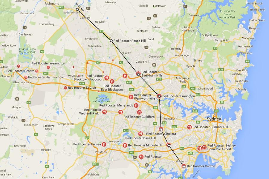
You’ve probably heard of the Red Rooster Line. And if you haven’t, well…looks like you’re about to. The Red Rooster Line is a method of marking the socio-economic divide between the haves and have-nots in the Sydney suburbs via mapping of the locations of Red Rooster outlets. It’s not what you might call an exact science, but the line runs from Sydney’s south-east to the north-west. On the south and west of the line, the Red Rooster proliferate and the suburbs tend towards the working class little Aussie battlers. On the north and east of it, there’s nary a Rippa Sub to be seen, and people are more likely to have opinions about wine. It’s also called the Chicken Curtain, and it’s one way of determining the exact definition of “western Sydney”, that vast amorphous mass that politicians are extremely interested in. The idea is that fast food is native to the west, and an unwelcome interloper at best on the snooty side of the curtain. The chicken chain El Jannah, however, is set to throw everything into disarray, with its plans to open a location in Newtown. The inner-west iteration of the chicken shop will be an outpost of westiness in the heart of urban hipsterville, and could lead to a revolution in the way we think about chicken and class. It’ll be El Jannah’s most easterly expansion yet, and could lead to ever more incursions from the fast food barbarians. How soon until we see Red Rooster’s parma burgers being munched along Oxford Street? Only time will tell.

Sydney Fast-Food Divide FAQs
What is the Red Rooster line?
The Red Rooster line shows the socio-economic divide between the city’s suburb demographics using the locations of red rooster fast-food chains.


Comments
We love hearing from you. or to leave a comment.